| at: |
Homochitto National Forest |
Data from USFS GIS
 show on map
 animate
Trail users:


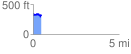
Elevation Profile
 0.486903 mi
 81.20 ft
 124.79 ft
 -43.59 ft
 4.85 %
GPX Downloads: Track Route
![]()
| at: |
Homochitto National Forest |
show on map
animate
0.486903 mi
81.20 ft
124.79 ft
-43.59 ft
4.85 %