| at: |
Homochitto National Forest |
Data from USFS GIS
 show on map
 animate
Trail users:


Elevation Profile
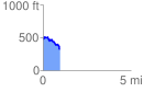
 0.967921 mi
 95.10 ft
 251.89 ft
 -156.79 ft
 4.93 %
GPX Downloads: Track Route
![]()
| at: |
Homochitto National Forest |
show on map
animate
0.967921 mi
95.10 ft
251.89 ft
-156.79 ft
4.93 %