| at: |
Homochitto National Forest |
Data from USFS GIS
 show on map
 animate
Trail users:


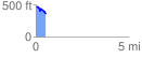
Elevation Profile
 0.531891 mi
 38.15 ft
 163.63 ft
 -125.48 ft
 5.83 %
GPX Downloads: Track Route
![]()
| at: |
Homochitto National Forest |
show on map
animate
0.531891 mi
38.15 ft
163.63 ft
-125.48 ft
5.83 %