| at: |
Homochitto National Forest |
Data from USFS GIS
 show on map
 animate
Trail users:


Elevation Profile
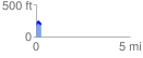
 0.256293 mi
 72.95 ft
 58.43 ft
 14.52 ft
 5.39 %
GPX Downloads: Track Route
![]()
| at: |
Homochitto National Forest |
show on map
animate
0.256293 mi
72.95 ft
58.43 ft
14.52 ft
5.39 %