| at: |
Homochitto National Forest |
Data from USFS GIS
 show on map
 animate
Trail users:


Elevation Profile
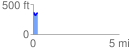
 0.268180 mi
 56.90 ft
 50.19 ft
 6.72 ft
 4.02 %
GPX Downloads: Track Route
![]()
| at: |
Homochitto National Forest |
show on map
animate
0.268180 mi
56.90 ft
50.19 ft
6.72 ft
4.02 %