| at: |
Homochitto National Forest |
Data from USFS GIS
 show on map
 animate
Trail users:


Elevation Profile
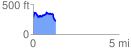
 1.326314 mi
 233.92 ft
 299.75 ft
 -65.83 ft
 4.28 %
GPX Downloads: Track Route
![]()
| at: |
Homochitto National Forest |
show on map
animate
1.326314 mi
233.92 ft
299.75 ft
-65.83 ft
4.28 %