| at: |
Homochitto National Forest |
Data from USFS GIS
 show on map
 animate
Trail users:


Elevation Profile
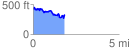
 1.874993 mi
 369.47 ft
 442.18 ft
 -72.71 ft
 4.47 %
GPX Downloads: Track Route
![]()
| at: |
Homochitto National Forest |
show on map
animate
1.874993 mi
369.47 ft
442.18 ft
-72.71 ft
4.47 %