| at: |
Homochitto National Forest |
Data from USFS GIS
 show on map
 animate
Trail users:


Elevation Profile
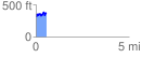
 0.553369 mi
 145.80 ft
 134.03 ft
 11.77 ft
 4.99 %
GPX Downloads: Track Route
![]()
| at: |
Homochitto National Forest |
show on map
animate
0.553369 mi
145.80 ft
134.03 ft
11.77 ft
4.99 %