| at: |
Homochitto National Forest |
Data from USFS GIS
 show on map
 animate
Trail users:


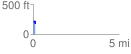
Elevation Profile
 0.148968 mi
 14.09 ft
 68.55 ft
 -54.47 ft
 8.72 %
GPX Downloads: Track Route
![]()
| at: |
Homochitto National Forest |
show on map
animate
0.148968 mi
14.09 ft
68.55 ft
-54.47 ft
8.72 %