| at: |
Homochitto National Forest |
Data from USFS GIS
 show on map
 animate
Trail users:


Elevation Profile
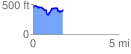
 1.739438 mi
 258.84 ft
 278.39 ft
 -19.56 ft
 3.03 %
GPX Downloads: Track Route
![]()
| at: |
Homochitto National Forest |
show on map
animate
1.739438 mi
258.84 ft
278.39 ft
-19.56 ft
3.03 %