|
| at: |
Homochitto National Forest |
Data from USFS GIS
 show on map
 animate
Trail users:


Elevation Profile
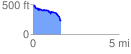
 1.657215 mi
 229.83 ft
 430.07 ft
 -200.23 ft
 4.92 %
GPX Downloads: Track Route
![]()
|
| at: |
Homochitto National Forest |
show on map
animate
1.657215 mi
229.83 ft
430.07 ft
-200.23 ft
4.92 %