| at: |
Homochitto National Forest |
Data from USFS GIS
 show on map
 animate
Trail users:


Elevation Profile
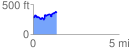
 1.371618 mi
 297.72 ft
 213.70 ft
 84.02 ft
 4.11 %
GPX Downloads: Track Route
![]()
| at: |
Homochitto National Forest |
show on map
animate
1.371618 mi
297.72 ft
213.70 ft
84.02 ft
4.11 %