| at: |
Homochitto National Forest |
Data from USFS GIS
 show on map
 animate
Trail users:


Elevation Profile
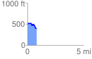
 0.816937 mi
 57.70 ft
 184.16 ft
 -126.46 ft
 4.27 %
GPX Downloads: Track Route
![]()
| at: |
Homochitto National Forest |
show on map
animate
0.816937 mi
57.70 ft
184.16 ft
-126.46 ft
4.27 %