|
| at: |
Homochitto National Forest |
Data from USFS GIS
 show on map
 animate
Trail users:


Elevation Profile
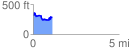
 1.114730 mi
 178.52 ft
 228.79 ft
 -50.28 ft
 3.89 %
GPX Downloads: Track Route
![]()
|
| at: |
Homochitto National Forest |
show on map
animate
1.114730 mi
178.52 ft
228.79 ft
-50.28 ft
3.89 %