|
| at: |
Homochitto National Forest |
Data from USFS GIS
 show on map
 animate
Trail users:


Elevation Profile
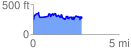
 2.854864 mi
 678.85 ft
 684.10 ft
 -5.25 ft
 4.54 %
GPX Downloads: Track Route
![]()
|
| at: |
Homochitto National Forest |
show on map
animate
2.854864 mi
678.85 ft
684.10 ft
-5.25 ft
4.54 %