| at: |
Homochitto National Forest |
Data from USFS GIS
 show on map
 animate
Trail users:


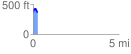
Elevation Profile
 0.262114 mi
 72.29 ft
 76.87 ft
 -4.58 ft
 5.55 %
GPX Downloads: Track Route
![]()
| at: |
Homochitto National Forest |
show on map
animate
0.262114 mi
72.29 ft
76.87 ft
-4.58 ft
5.55 %