| at: |
Homochitto National Forest |
Data from USFS GIS
 show on map
 animate
Trail users:


Elevation Profile
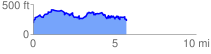
 5.740550 mi
 1447.96 ft
 1445.48 ft
 2.48 ft
 4.78 %
GPX Downloads: Track Route
![]()
| at: |
Homochitto National Forest |
show on map
animate
5.740550 mi
1447.96 ft
1445.48 ft
2.48 ft
4.78 %