|
| at: |
Kisatchie National Forest - Caney District |
Data from USFS GIS
 show on map
 animate
Trail users:


Elevation Profile
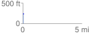
 0.092371 mi
 8.20 ft
 1.80 ft
 6.40 ft
 1.68 %
GPX Downloads: Track Route
![]()
|
| at: |
Kisatchie National Forest - Caney District |
show on map
animate
0.092371 mi
8.20 ft
1.80 ft
6.40 ft
1.68 %