| at: |
Kisatchie National Forest - Caney District |
Data from USFS GIS
 show on map
 animate
Trail users:


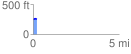
Elevation Profile
 0.203073 mi
 21.99 ft
 11.63 ft
 10.36 ft
 2.05 %
GPX Downloads: Track Route
![]()
| at: |
Kisatchie National Forest - Caney District |
show on map
animate
0.203073 mi
21.99 ft
11.63 ft
10.36 ft
2.05 %