| at: |
Rock Creek/Tatum Lead ORV Trails Mulberry Gap |
Data from David Muse
 show on map
 animate
Trail users:


Elevation Profile
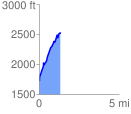
 1.347597 mi
 897.53 ft
 95.04 ft
 802.49 ft
 12.61 %
GPX Downloads: Track Route
![]()
| at: |
Rock Creek/Tatum Lead ORV Trails Mulberry Gap |
show on map
animate
1.347597 mi
897.53 ft
95.04 ft
802.49 ft
12.61 %