|
| at: |
Kisatchie National Forest - Caney District |
Data from USFS GIS
 show on map
 animate
Trail users:


Elevation Profile
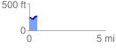
 0.542131 mi
 59.45 ft
 31.72 ft
 27.74 ft
 2.08 %
GPX Downloads: Track Route
![]()
|
| at: |
Kisatchie National Forest - Caney District |
show on map
animate
0.542131 mi
59.45 ft
31.72 ft
27.74 ft
2.08 %