| at: |
Kisatchie National Forest - Caney District |
Data from USFS GIS
 show on map
 animate
Trail users:


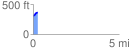
Elevation Profile
 0.263847 mi
 67.65 ft
 2.23 ft
 65.42 ft
 4.86 %
GPX Downloads: Track Route
![]()
| at: |
Kisatchie National Forest - Caney District |
show on map
animate
0.263847 mi
67.65 ft
2.23 ft
65.42 ft
4.86 %