| at: |
Kisatchie National Forest - Caney District |
Data from USFS GIS
 show on map
 animate
Trail users:


Elevation Profile
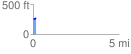
 0.189623 mi
 31.56 ft
 10.93 ft
 20.63 ft
 3.15 %
GPX Downloads: Track Route
![]()
| at: |
Kisatchie National Forest - Caney District |
show on map
animate
0.189623 mi
31.56 ft
10.93 ft
20.63 ft
3.15 %