| at: |
Kisatchie National Forest - Caney District |
Data from USFS GIS
 show on map
 animate
Trail users:


Elevation Profile
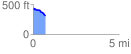
 0.710763 mi
 10.60 ft
 145.55 ft
 -134.94 ft
 3.88 %
GPX Downloads: Track Route
![]()
| at: |
Kisatchie National Forest - Caney District |
show on map
animate
0.710763 mi
10.60 ft
145.55 ft
-134.94 ft
3.88 %