| at: |
Kisatchie National Forest - Caney District |
Data from USFS GIS
 show on map
 animate
Trail users:


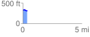
Elevation Profile
 0.387823 mi
 6.84 ft
 35.21 ft
 -28.37 ft
 1.72 %
GPX Downloads: Track Route
![]()
| at: |
Kisatchie National Forest - Caney District |
show on map
animate
0.387823 mi
6.84 ft
35.21 ft
-28.37 ft
1.72 %