| at: |
Fort Mountain State Park Area Rock Creek/Tatum Lead ORV Trails |
Data from David Muse
 show on map
 animate
Trail users:


Elevation Profile
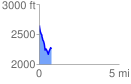
 0.764009 mi
 119.31 ft
 512.34 ft
 -393.03 ft
 12.70 %
GPX Downloads: Track Route
![]()
| at: |
Fort Mountain State Park Area Rock Creek/Tatum Lead ORV Trails |
show on map
animate
0.764009 mi
119.31 ft
512.34 ft
-393.03 ft
12.70 %