|
| at: |
Kisatchie National Forest - Winn/Catahoula Districts |
Data from USFS GIS
 show on map
 animate
Trail users:


Elevation Profile
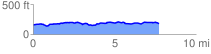
 7.794454 mi
 360.92 ft
 352.14 ft
 8.78 ft
 0.88 %
GPX Downloads: Track Route
![]()
|
| at: |
Kisatchie National Forest - Winn/Catahoula Districts |
show on map
animate
7.794454 mi
360.92 ft
352.14 ft
8.78 ft
0.88 %