| at: |
Kisatchie National Forest - Winn/Catahoula Districts |
Data from USFS GIS
 show on map
 animate
Trail users:


Elevation Profile
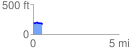
 0.543933 mi
 27.03 ft
 56.41 ft
 -29.37 ft
 1.96 %
GPX Downloads: Track Route
![]()
| at: |
Kisatchie National Forest - Winn/Catahoula Districts |
show on map
animate
0.543933 mi
27.03 ft
56.41 ft
-29.37 ft
1.96 %