|
| at: |
Kisatchie National Forest - Winn/Catahoula Districts |
Data from USFS GIS
 show on map
 animate
Trail users:


Elevation Profile
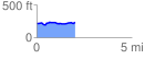
 2.045765 mi
 94.05 ft
 76.69 ft
 17.36 ft
 0.87 %
GPX Downloads: Track Route
![]()
|
| at: |
Kisatchie National Forest - Winn/Catahoula Districts |
show on map
animate
2.045765 mi
94.05 ft
76.69 ft
17.36 ft
0.87 %