|
| at: |
Kisatchie National Forest - Winn/Catahoula Districts |
Data from USFS GIS
 show on map
 animate
Trail users:


Elevation Profile
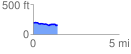
 1.418521 mi
 45.98 ft
 79.88 ft
 -33.89 ft
 1.07 %
GPX Downloads: Track Route
![]()
|
| at: |
Kisatchie National Forest - Winn/Catahoula Districts |
show on map
animate
1.418521 mi
45.98 ft
79.88 ft
-33.89 ft
1.07 %