|
| at: |
Kisatchie National Forest - Winn/Catahoula Districts |
Data from USFS GIS
 show on map
 animate
Trail users:


Elevation Profile
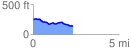
 2.318576 mi
 73.28 ft
 181.94 ft
 -108.67 ft
 1.49 %
GPX Downloads: Track Route
![]()
|
| at: |
Kisatchie National Forest - Winn/Catahoula Districts |
show on map
animate
2.318576 mi
73.28 ft
181.94 ft
-108.67 ft
1.49 %