|
| at: |
Kisatchie National Forest - Winn/Catahoula Districts |
Data from USFS GIS
 show on map
 animate
Trail users:


Elevation Profile
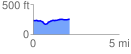
 2.113218 mi
 112.55 ft
 103.50 ft
 9.05 ft
 1.01 %
GPX Downloads: Track Route
![]()
|
| at: |
Kisatchie National Forest - Winn/Catahoula Districts |
show on map
animate
2.113218 mi
112.55 ft
103.50 ft
9.05 ft
1.01 %