|
| at: |
Swallow Creek WMA |
Data from David Muse
 show on map
 animate
Trail users:


Elevation Profile
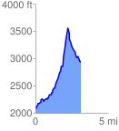
 3.136515 mi
 1561.13 ft
 697.88 ft
 863.25 ft
 9.43 %
GPX Downloads: Track Route
![]()
|
| at: |
Swallow Creek WMA |
show on map
animate
3.136515 mi
1561.13 ft
697.88 ft
863.25 ft
9.43 %