| at: |
Coleman River Scenic Area |
Data from David Muse
 show on map
 animate
Trail users:


Elevation Profile
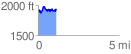
 1.110490 mi
 272.03 ft
 223.86 ft
 48.17 ft
 4.64 %
GPX Downloads: Track Route
![]()
| at: |
Coleman River Scenic Area |
show on map
animate
1.110490 mi
272.03 ft
223.86 ft
48.17 ft
4.64 %