| at: |
Coleman River Scenic Area |
Data from David Muse
 show on map
 animate
Trail users:


Elevation Profile
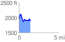
 1.437313 mi
 370.42 ft
 409.77 ft
 -39.35 ft
 5.40 %
GPX Downloads: Track Route
![]()
| at: |
Coleman River Scenic Area |
show on map
animate
1.437313 mi
370.42 ft
409.77 ft
-39.35 ft
5.40 %