| at: |
Coleman River Scenic Area |
Data from David Muse
 show on map
 animate
Trail users:


Elevation Profile
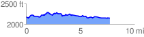
 7.820441 mi
 594.65 ft
 645.72 ft
 -51.07 ft
 1.56 %
GPX Downloads: Track Route
![]()
| at: |
Coleman River Scenic Area |
show on map
animate
7.820441 mi
594.65 ft
645.72 ft
-51.07 ft
1.56 %