| at: |
Coleman River Scenic Area |
Data from David Muse
 show on map
 animate
Trail users:


Elevation Profile
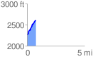
 0.769838 mi
 369.36 ft
 18.81 ft
 350.55 ft
 9.09 %
GPX Downloads: Track Route
![]()
| at: |
Coleman River Scenic Area |
show on map
animate
0.769838 mi
369.36 ft
18.81 ft
350.55 ft
9.09 %