|
| at: |
Coleman River Scenic Area |
Data from David Muse
 show on map
 animate
Trail users:


Elevation Profile
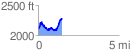
 1.471824 mi
 451.11 ft
 268.48 ft
 182.63 ft
 5.80 %
GPX Downloads: Track Route
![]()
|
| at: |
Coleman River Scenic Area |
show on map
animate
1.471824 mi
451.11 ft
268.48 ft
182.63 ft
5.80 %