|
| at: |
Coleman River Scenic Area |
Data from David Muse
 show on map
 animate
Trail users:


Elevation Profile
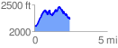
 2.490375 mi
 783.70 ft
 657.44 ft
 126.26 ft
 5.96 %
GPX Downloads: Track Route
![]()
|
| at: |
Coleman River Scenic Area |
show on map
animate
2.490375 mi
783.70 ft
657.44 ft
126.26 ft
5.96 %