|
| at: |
Kisatchie National Forest - Winn/Catahoula Districts |
Data from USFS GIS
 show on map
 animate
Trail users:


Elevation Profile
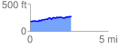
 2.648287 mi
 189.75 ft
 100.95 ft
 88.80 ft
 1.36 %
GPX Downloads: Track Route
![]()
|
| at: |
Kisatchie National Forest - Winn/Catahoula Districts |
show on map
animate
2.648287 mi
189.75 ft
100.95 ft
88.80 ft
1.36 %