| at: |
Kisatchie National Forest - Kisatchie District |
Data from USFS GIS
 show on map
 animate
Trail users:


Elevation Profile
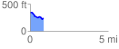
 0.862558 mi
 33.14 ft
 143.93 ft
 -110.79 ft
 3.16 %
GPX Downloads: Track Route
![]()
| at: |
Kisatchie National Forest - Kisatchie District |
show on map
animate
0.862558 mi
33.14 ft
143.93 ft
-110.79 ft
3.16 %