| at: |
Kisatchie National Forest - Kisatchie District |
Data from USFS GIS
 show on map
 animate
Trail users:


Elevation Profile
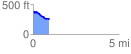
 0.944617 mi
 46.72 ft
 179.07 ft
 -132.35 ft
 3.59 %
GPX Downloads: Track Route
![]()
| at: |
Kisatchie National Forest - Kisatchie District |
show on map
animate
0.944617 mi
46.72 ft
179.07 ft
-132.35 ft
3.59 %