| at: |
Kisatchie National Forest - Kisatchie District |
Data from USFS GIS
 show on map
 animate
Trail users:


Elevation Profile
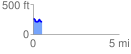
 0.540288 mi
 50.91 ft
 94.12 ft
 -43.21 ft
 3.30 %
GPX Downloads: Track Route
![]()
| at: |
Kisatchie National Forest - Kisatchie District |
show on map
animate
0.540288 mi
50.91 ft
94.12 ft
-43.21 ft
3.30 %