| at: |
Kisatchie National Forest - Kisatchie District |
Data from USFS GIS
 show on map
 animate
Trail users:


Elevation Profile
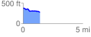
 1.431543 mi
 40.36 ft
 144.30 ft
 -103.94 ft
 1.91 %
GPX Downloads: Track Route
![]()
| at: |
Kisatchie National Forest - Kisatchie District |
show on map
animate
1.431543 mi
40.36 ft
144.30 ft
-103.94 ft
1.91 %