|
| at: |
Kisatchie National Forest - Kisatchie District |
Data from USFS GIS
 show on map
 animate
Trail users:


Elevation Profile
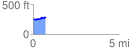
 0.764497 mi
 81.23 ft
 35.74 ft
 45.49 ft
 2.01 %
GPX Downloads: Track Route
![]()
|
| at: |
Kisatchie National Forest - Kisatchie District |
show on map
animate
0.764497 mi
81.23 ft
35.74 ft
45.49 ft
2.01 %