| at: |
Kisatchie National Forest - Kisatchie District |
Data from USFS GIS
 show on map
 animate
Trail users:


Elevation Profile
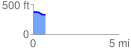
 0.722060 mi
 13.72 ft
 47.74 ft
 -34.03 ft
 1.25 %
GPX Downloads: Track Route
![]()
| at: |
Kisatchie National Forest - Kisatchie District |
show on map
animate
0.722060 mi
13.72 ft
47.74 ft
-34.03 ft
1.25 %