|
| at: |
Kisatchie National Forest - Kisatchie District |
Data from USFS GIS
 show on map
 animate
Trail users:


Elevation Profile
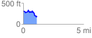
 1.144007 mi
 117.82 ft
 261.01 ft
 -143.19 ft
 4.32 %
GPX Downloads: Track Route
![]()
|
| at: |
Kisatchie National Forest - Kisatchie District |
show on map
animate
1.144007 mi
117.82 ft
261.01 ft
-143.19 ft
4.32 %