| at: |
Kisatchie National Forest - Kisatchie District |
Data from USFS GIS
 show on map
 animate
Trail users:


Elevation Profile
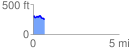
 0.650497 mi
 44.01 ft
 98.11 ft
 -54.10 ft
 2.86 %
GPX Downloads: Track Route
![]()
| at: |
Kisatchie National Forest - Kisatchie District |
show on map
animate
0.650497 mi
44.01 ft
98.11 ft
-54.10 ft
2.86 %