| at: |
Kisatchie National Forest - Kisatchie District |
Data from USFS GIS
 show on map
 animate
Trail users:


Elevation Profile
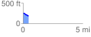
 0.462928 mi
 8.46 ft
 70.21 ft
 -61.75 ft
 2.87 %
GPX Downloads: Track Route
![]()
| at: |
Kisatchie National Forest - Kisatchie District |
show on map
animate
0.462928 mi
8.46 ft
70.21 ft
-61.75 ft
2.87 %