| at: |
Kisatchie National Forest - Kisatchie District |
Data from USFS GIS
 show on map
 animate
Trail users:


Elevation Profile
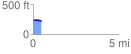
 0.471848 mi
 10.92 ft
 22.75 ft
 -11.82 ft
 0.91 %
GPX Downloads: Track Route
![]()
| at: |
Kisatchie National Forest - Kisatchie District |
show on map
animate
0.471848 mi
10.92 ft
22.75 ft
-11.82 ft
0.91 %